
September is the highest hurricane watch for the United States Virgin Islands. In the year 2017, the Island had back-to-back category 5 hurricanes. A massive hurricane Irma came in with a shifting wind speed gusting at 185-220 strength, heading directly to the island on September 6, 2017, as devastation came through everything in its path and destroyed poles, trees, and many homes and businesses. Then two weeks later, Hurricane Maria on September 15, 2017, with high speed at 165-187 winds and rain as the hurricane shifted and scrabbled what was already into pieces and took more homes and businesses to their last standing. The islands were devastatingly flooded and scattered with broken trees, lifeless animals, and debris. To see pictures and videos of what the power of a hurricane can do, we must follow the ground rules in Preparations and Safety.
What is a Hurricane?
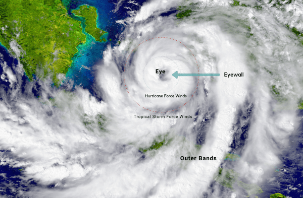
Hurricanes are high-pressure or intense encircling belt cyclopes. That forms an amount of heat that releases cloudy diffused matter. It is a vapor that is evanescent from the ocean and condenses to heavy rainfalls and strong winds. The hurricane forms a vortex of upper air currents spinning clockwise.
By all means necessary, you must prepare for a hurricane before it reaches its path of devastation. Please plan for people who are vacationing on the island during the hurricane season. If you may, try not to plan your vacation in September on the United States Virgin Islands. It is a very critical time during the hurricane season.
Tips for Vacationers
- Make sure you have cash.
- Have boots, extra clothes, long sleeves, and long pants.
- Purchase bug repellent.
- Ziplock all your important documents, ID, passport, etc. and keep them at hand.
- Carry a cell phone battery backup, small radio, and extra batteries.
- Flashlights.
- Bottled water and snacks.
- A pocket knife and hammer.
- Emergency medical kit with cough and cold medicines.
- Cell phone with local (AT&T) services.
Hurricane Trade Winds are the most extensive wind flow westward in the direction of the equator. As the trade winds progress, the air mass transfigures humidity and dissipated rain clouds. Independently, the wind rate indicates pressure as an alternative to atmospheric motion. Its pressure is equivalent to the refinement of air preposition on the earth’s atmosphere or surface.
How strong can a Hurricane get?
Hurricane winds may adopt a pressure of more than 400 kilograms per square meter to 82 pounds per square foot winds. However, it can destroy everything in its path. A hurricane can export more than 3,500,000,000 tons of air per hour. A hurricane is very serious; it gets stronger and more intense every year. Our lives depend on proper weather coverage in times of hurricane season.
How can you be certain it’s a strong hurricane?
Times of technology online or broadcasting weather reports from professional radiologists are prepared to give reports that are very important to listen to and take proper precautions. Stay out of harm’s way when these reports are broadcast, it is real and accurate to their safety measures. When you hear or read about a storm or hurricane measures, that’s when you will know a hurricane’s strength.
Hurricanes are a form of stormy weather off Africa or South America till they accumulate over the ocean forming latitude of trade winds in the tropical water at a low pressure near the equator margins. The hurricane centers of high pressure may elongate subtropical areas into the middle latitude. Hurricanes emerge from air characteristics that generate warm, dry conditions with ample sunlight in the eastern extremes of subtropical Atlantic Ocean basins.
How do clouds form in a hurricane?
Clouds form from damp air, which cools by lower pressure that exists at high levels in the atmosphere. They form in regions of upward impetus if sufficient moisture is present and dissipates in this of the downward impetus. The widespread layer of clouds conjoins with tropical depression, in which the layers of clouds are formed by the widespread anomalous motion or turbulence. Then the cumulus clouds form by admittance convection and the orographic clouds form by an upward incline air over hills and mountains. These prominent clouds, and warm, moist maritime tropical air form over tropical and subtropical ocean waters with high pressure.
Hurricane Sea Levels’ high and low-pressure centers are caused by differential latitudes between the Atlantic and Pacific Oceans, which is the atmospheric pressure and horizontal wind that changes in wind direction and speed to capitulate mathematical zonal and meridian wind speed. The angular velocity of the earth’s rotation latitude, air density (mass per unit volume), pressure, and distance towards the earth’s directions. The geographic balance of sea levels and capitulate most field winds.

Hurricane Jet Streams are vigorous winds that are upper air circulations at a surfeit of 30 meters per second, it modifies thermal winds equation above areas of exceedingly sturdy temperatures gradients frontal zones. Which induces wind speeds that aggrandize heights of temperature gradients in the same direction, and frequently can hinder in forecasting changes in air mass, hence in temperatures and weather aloft regions. These jet streams form a signed band in high latitudes by sporadic periods of conversation. However, it is an important factor in high-altitude jet flights to navigate through wind speed and time in reaching their flight destination in the weathering report system.

Final words for St. Croix Visitors
Stay safe.
Stay inside.
Be prepared.
I was living in St Croix 2017 and experienced Irma and Maria. Luckily we only flooding but had to rip out the whole 1st floor because of black mold. Everyone was safe and that was most important.
Irma sounded like a vacuum and she peal all the tree leaves until the tree trunk tuned black, she came with a sting of wind, And Maria was a flood mess.